Kakhovka Reservoir water levels drop by 10 meters, effectively making it a river – Ukrainian ecologists
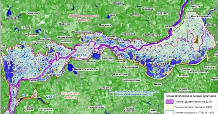
На супутниковому знімку виділено канал води. Фото:Sentinel-2А/ НАН України/ ДСНС України

Scientists at the Ukrainian Hydrometeorological Institute have dived into spectral-zone images of the Kakhovka Reservoir provided by the European Space Agency.
In addition to their high resolution, the images make it possible to identify areas covered with water with a high percentage of accuracy.
These images show numerous very small reservoirs with an area of about 0.1 km². They are not connected in any way to other reservoirs or the Dnipro riverbed and its branches, so they will quickly dry up.
However, there are also larger water bodies connected to the main channel. They indicate deeper parts of the reservoir.

Фото: Sentinel-2A
One can see that the boundary between the land and the water surface is approximately 10 meters. This means that the Kakhovka Reservoir has been drained to a depth of 10 meters. The same figure shows other isobaths corresponding to a depth of 11 or 12 meters.
The water level drainage itself is also visible on the Sentinel-2A satellite image taken in the visible spectrum. A significant part of the reservoir area has a light brown color, typical for a dry surface.
We are currently witnessing the formation, or rather, the restoration of the Dnipro River channel, the scientists report.
The new river formed on the site of the Kakhovka Reservoir will dry up in the dry season and fill up with water again in the wet season.